Tuesday, August 31, 2010

Day 53and 54 Traveling down the Cassiar Hwy, BC

Saturday and Sunday - August 21st and 22nd

Note: We have been without internet access for 6-days so I am behind!!!

The Cassiar Hwy (completed in 1972) connects the Alaskan Hwy at the BC-YK border to the Yellowhead Hwy in East-Central BC.

Our entrance from the North had been closed due to a “dry-lightening” forest fire that started July 27th. The day we arrived they were allowing single-lane traffic one-way by following a “pilot vehicle”. With our 1-hour delay, Wm and I played cribbage and Peter walked and chatted with the other folks in queue.

The smoke was thick and there were still a few hot fires.

This is a sparsely populated road so no homes or people appeared to be directly affected.

It was a beautiful drive despite the smoke and the area’s “welcomed” rainy weather.

We must have brought the rain as we have been in it since August 17th.


If you like Green, Jade City (pop. 50) would be the stop for you.

It is not so much a city as it is a community of Jade businesses.

We passed it by but in hindsight, it would have been very interesting.

The “Jade Mines” in the Cassiar Mountain Range produce 90% of the world’s supply!


“Bear Glacier”

We took a spur (side-road) off the Cassiar Hwy to Stewart, BC, (pop. 700) and Hyder, AK, (pop. 100).

The short drive has great views of the mountains and glaciers.

“Bear Glacier” close-up!

Hyder is the most Easterly town in Alaska and is separated from Stewart, BC, by a narrow fjord, the Portland Canal.

This is an ice-free port BUT they get 30-feet of snow in the winter. One can only get to Hyder by driving through BC as there is no ferry service to either community. Hyder citizens live on the BC time-zone except for the Post-Office, which is a Federal operation.

Both communities had their hey-days in 1917-1918 when silver was discovered in the area and the population was 10,000!


Today, tourists come to see bears (black and grizzly) at the Fish Creek Wildlife Viewing Area from mid-July through early September during the Salmon run – located in the Tongass National Forest.


The fish were there - Unfortunately, the “bears” missed their “viewing appointment”!

We weren’t the only ones disappointed as there were “thousands-of-dollars” in camera gear waiting on the viewing-boardwalk to snap “bear” photos.

Everyone had their cameras covered with plastic as, of course, it was raining again!

We did “Gull Viewing” instead!

Tongass National Forest is the largest of America’s national forests.

It encompasses nearly 17 million acres of land, 11,000 miles of shoreline and is the largest protected temperate rain forest in the world.

Each year more than 16 feet of rain falls in some areas of the Tongass.


This Raven was “berry picking.”

_______________________


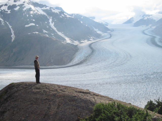
Since the bears didn’t show, we drove up the mountain to view the spectacular

Salmon Glacier.


Scenic View on the road to Salmon Glacier

_____________________


Wildflower

This small plant was growing on the hillside near the top of Salmon Glacier.

"Saxifrage"

Monday, August 23, 2010

Day 51 and 52 The Beginning of Vacation’s End

(Do retirees really call it vacation?)

Nabesna Rd, AK to Kluane Lake, YK to Continental Divide, YK

640-miles

Thursday and Friday, August 19th and 20th


We are now heading east and retracing our Alaska Highway route from Tok, AK to Watson Lake, Yk.

No touring at Whitehorse – grocery stop only!


Signs of Fall are now in the air.

The Cottonwood Cmpgrd on Kluane Lake has had frost and new snow in the nearby Mountains.

Kluane Lake - The leaves are changing color too!


_____________________


This hand carved Eagle decorated a Gift Shop door at one of our Fuel stops along the way.

Cute but we didn't buy it.

__________________

Our traveling fare is sandwiches!

William and I travel “All Wrapped Up”.......


.....while Peter prefers the less adventuresome “Sliced Bread” route.

_______________________


The Wildflowers are "talking fall" too.

The Wild Roses of summer……


…. have transitioned to Rose Hips.

“These fleshy fruits are rich in “Vitamin C” and make a tasty jam or tea” –

Per Ben Gadd’s handbook of the Canadian Rockies


Sunday, August 22, 2010

Day 49 and 50 To Nebesna Rd 114 Miles

Tuesday and Wednesday - August 17th and 18th

On the Road Again heading to the northern entrance of Wrangell/St. Elias National Park and Preserve with a short stop at Copper Center.

Copper Center (population 362/half Athabascan), off the Richardson Hwy and 105-miles north of Valdez, was founded in 1896 as a government agricultural experiment station.

It was the first white settlement in this area. 300 miners, destitute and hungry spent the winter of 1898 here after crossing the Valdez; Many suffered with scurvy and died.

Remember what causes scurvy? Lack of Vitamin C!

This is one of the two original log bunkhouses used for the “Historical Museum.”


Authentic descendent of the original 1896 roadhouse.

___________________


The northern entrance to Wrangell/St. Elias NP is along the 42-mile Nabesna Road which goes through a “permafrost” portion of the park.

According to the Park’s publication, “You won’t find many people, so if you like taking the road less traveled, Nabesna Road might be right for you.” They aren’t kidding!

Slana refers to this general unincorporated area ( population 94.)


A stream along the road.

The road was built in 1933 allowing the removal of $2-million worth of gold from the Nabesna Mine before it closed in 1942. The mine and buildings at the end of the road are privately owned so “No tours”!


We took a short hike on the Caribou Trail.
As you can see, ATV's are allowed to use this trail also. And Yes - is was raining, again.


The trail is on permafrost so it was like walking on a cushion - except for the muddy ATV ruts!


As luck would have it, the wild Blueberries were ripe.

Fortunately the Bears were not out picking at the same time we were!


We managed to collect one-cup’s worth and put them in our pancakes the next morning.


A bit of Mother Nature’s gardening along the trail.


The place we camped at on the Nabesna Rd was a step back in time.

Business was not booming - We were the only folks!

We spent 2 nights here hoping the rain and clouds would go away – they didn’t!


How many of these have you scene in the last year???


Does anyone remember Oliver tractors?


____________________


We celebrated Peter’s 63rd Birthday with Ghirardelli Brownies.

We would all rate this brand of brownie mix as a “10”.


______________________

Cotton Grass

Growing along the Nabesna Road - I have not seen it before.


Thursday, August 19, 2010

Day 47 and 48 Valdez to Kenny Lake/McCarthy Road - 95 Miles

August 15th and 16th

We made the short trip to stay near the southern entrance to Wrangell-St. Elias Nat’l Park & Preserve;

the “Kenny Lake Mercantile and Campground” became our home for two- nights.

We drove/bounced into the park on the McCarthy Road (a 60-mile old railroad bed) which took us 3 hours to get to the end because of all the washboards and potholes!


Scenic view -1 along the McCarthy Road

Scenic view - 2


The Copper River & Northwestern Railway was the lifeline for the Kennecott Copper Mine. It was completed in 1911 after building numerous trestles to cross the many rivers.
The McCarthy Road follows most of the old rail-bed.

(a park billboard photo)

The single lane Kuskulana Bridge was built in 1910;
it spans 525-feet and is 238-feet above the river.


The Kuskulana River

We decided to walk back over the Kuskulana Bridge to take some pictures!
Anyone afraid of heights? I wasn't too comfortable.


Just before the McCarthy Road begins is the small rustic town of Chitina; (an old Athabascan village) that was born in 1910 as a way-station for the railroad that served the mine/communities.
This is one of the refurbished buildings.

This is not!


Your might even get a good deal on this car sitting across the street from the Chitina Hotel!


The two settlements at the end of the road, Kennecott and McCarthy, both originated with the establishment of the Kennecott Mines Company (copper) in 1906.
Neither town is accessible by car.
This is a half-mile "Park & Walk" operation over the Copper River to McCarthy.


Then you pay $5, one-way, to get a shuttle to Kennecott.


Main Street in McCarthy.
Today the area has a population of 54 with privately owned houses interspersed with National Park property.


According to the book, The Rough Guide to Alaska the towns have
“…ancient log cabins, frame houses pieced together from whatever was available, and assorted rusting hulks which give the town a kind of junkyard beauty.”


The mining buildings in Kennecott.
(The mine its-self is 5-miles further up the mountain.)
Some have been refubished by the National Park.


Many have not!


I'm glad this wasn't us as we headed home from the day's venture.

______________


The Wild Geranium!


You can see why it is also called "Crane's Bill"
(what it looks like after it goes to seed)