Saturday, July 17, 2010

Day 16 & 17 - Haines Junction, YK

July 15th and 16th

Haines Junction

Population 860 – Elevation 1,956 feet


Haines Junction is at the junction of the Haines Hwy and the Alaskan Hwy in the SW part of the Yukon. It was established in 1942 during the construction of the Alaska Hwy as an Army barracks for the Army Corps of Engineers who were to build the road connecting the Alaska Hwy with the port of Haines (we were on the Haines Hwy yesterday). The town is on the eastern boundary of Kluane (pronounced kloo-WA-nee) National Park and Reserve.


There are mountains and lakes all around. This is the view from our campground.


Haines Junction’s “shopping center.” Madley’s Store

$5.05 for a quart of milk and Wm is drinking a lot of it!


Wm went for a 6-hour hike on the King's Throne Trail.


Another view from Wm's hike.


This was his view of Katherine Lake.


This was our view. We walked a bit on the shoreline. Much safer, don’t you think?


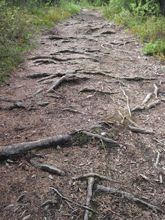
Wm and Mom hiking Auriol trail.


Auriol trail should be renamed "Root" trail.


Fireweed along Quill Creek.


Rock throwers along Quill Creek.

Do guys ever get too old to be throwing rocks into the water?


Kathleen Lake is home to the Kokanee salmon. They are Sockeye salmon that never return to the ocean for part of their life cycle. They spend their entire lives in freshwater.


Today's wildflower:

Monkshood

(in the buttercup family)

No comments:

Post a Comment